poniedziałek, 11 października 2021

Łubowice - pałac Eichendorffów

https://www.geocaching.com/geocache/GC58TKW

Lecz obumarli wszyscy, co mieszkali w starym domu i oglądają obcy go, jak gdyby powstał z grobu...


Pałac został wzniesiony w barokowym stylu w 1780 r. przez dziadka poety Josepha von Eichendorffa (on sam urodził się w nim w 1788r). Przebudowa w 1858 r. nadała pałacowi neogotyckie szaty. Po śmierci rodziców poety (w 1818 i 1822 r.) pałac został zlicytowany.

Kościół w Tropiu / Church In Tropie

https://www.geocaching.com/geocache/GC3Y68J 


[PL]
Kościół w Tropiu. Tropie rozwinęło się dzięki położeniu na szlaku handlowym Bizancjum-Bałtyk, ale znane stało się dzięki żyjącemu tu w latach 998 – 1018 św. Andrzejowi Świeradowi. Kult świętego rozpoczął się po jego śmierci, a sama miejscowość od XIV do XVII wieku funkcjonowała pod nazwą Święty Świerad. 

Jest to jedna z najstarszych świątyń w Małopolsce. Pierwszy, romański kościół pod wezwaniem śś Andrzeja i Benedykta ufundował w połowie XI w. Kazimierz Odnowiciel. Wewnątrz świątyni zachowały się romańskie freski z początku XII wieku – jedne z najstarszych w Europie oraz bezcenne malowidło ścienne przedstawiające św. Stefana, króla Węgier. W kościele znajdują się relikwie Krzyża Chrystusowego oraz relikwie św. Świerada, które ofiarował parafii w 1959 r. biskup z Nitry. 


Świątynia malowniczo położona na wzgórzu nad jeziorem Czchowskim, otoczona jest kamiennym różańcem, zaś między budowlą a źródłem św. Świerada zbudowano kalwarię polskich świętych. Nieopodal znajdują się legendarny dąb św. Świerada, oraz kaplica upamiętniająca miejsce gdzie znajdowała się jego pustelnia.


[EN]
Church In Tropie. Tropie developed on the trading route from Byzantium to the Baltic Sea, and became famous thanks to St Andrzej Świerad living here in 998 – 1018. The town itself was even known as Święty Świerad from 14th to 17th c. The church is one of Małopolska’s oldest. The original, Romanesque Church of St Andrew and St Benedict was founded in the mid-11th c. by King Casimir the Restorer. Preserved inside are Romanesque frescoes from the early 12th c., among the oldest in Europe, and the priceless mural presenting St Stephen, King of Hungary. The relics of the Cross of Christ and St Świerad were presented to the parish by the Bishop of Nitra ( Slovakia ) in 1959. The church is picturesquely situated on a hill overlooking the Czchów Reservior, and surrounded by a stone rosary. The Calvary of Polish Saints was built between the church and the spring of the saint. Nearby stands the legendary oak of St Świerad and a chapel that protects the place where his hermitage stood.


Zapora w Czchowie - The dam in Czchów

 https://www.geocaching.com/geocache/GC3N3BN


[PL]

Dla uniknięcia wahań poziomu wody poniżej zapory w Rożnowie i w związku z tym postępującej nadmiernej erozji brzegów Dunajca, rozpoczęto w 1936 r. w Czchowie budowę zapory i zbiornika wyrównawczego dla Jeziora Rożnowskiego. Budowę zapory w Czchowie ukończono w 1949 r. Jest to zapora betonowa o wysokości 16 m. W wyniku spiętrzenia rzeki Dunajec zapora stworzyła Jezioro Czchowskie. Powierzchnia tego zbiornika to 346 ha a maksymalna głębokość sięga nawet do 10 m. W korpus zapory wmontowano turbiny elektrowni wodnej. Montaż urządzeń energetycznych w Czchowie został całkowicie zakończony dopiero w 1954 r. Elektrownia wodna wyposażona jest w dwa hydrozespoły z turbinami Kaplana z regulacją położenia aparatu kierowniczego ustawiającego przepływ wody przez turbinę i regulacją łopat wirnika turbiny dla optymalizacji pracy turbiny i ograniczenia zjawisk kawitacyjnych. Moc zainstalowana każdej turbiny wynosi 4 MW przy 150 obr./min i przepływie wody przez turbinę 57 m³. Moc znamionowa generatorów wynosi 4,8.

Zespół zbiorników wodnych Rożnów-Czchów jest jednym z głównych elementów zagospodarowania zasobów wód dorzecza Dunajca. Podstawowe funkcje zespołu zbiorników to:

• przeciwpowodziowa (polega na wyrównaniu przepływów i ochronie dna dolin przed powodziami, zmniejszenie fali powodziowej Dunajca i Wisły),
• energetyczna (wykorzystanie wody do produkcji energii elektrycznej),
• zaopatrzenia w wodę,
• rekreacyjna i turystyczna,
• żeglugowa (wyrównując przepływy zbiorniki umożliwiają spływ na Dunajcu i żeglugę na Wiśle poniżej ujścia Dunajca).

[EN]

To avoid fluctuations of water level below the dam in Rożnów and progressive erosion canyon of Dunajec river, in 1936 started the construction of the dam in Czchów and the tank for lake Rożnowski. The construction of the dam in Czchów completed in 1949, is a concrete dam with a height of 16 m. By the damming of the river Dunajec dam created lake Czchowskie. Surface of the reservoir is 346 ha with a maximum depth reaches up to 10 meters In the body of the dam hydroelectric turbines was mounted. Installation of power equipment in Czchów was fully completed in 1954, hydroelectric power has two Kaplan turbines. The installed capacity of each turbine is 4 MW at 150 rev. / min and the flow of water through the turbine 57 m³. Rated power of generators is 4.8 MW.

Team reservoirs Rożnów-Czchów is one of the main development Dunajec river basin water resources. Basic functions of the team tanks are:

• Flood (flow equalization of the valley and protect against flooding, reduce flood wave of rivers Dunajec and Vistula)
• Energy (use water to generate electricity),
• water supply,
• recreation and tourism,
• Shipping (flow aligning tanks allow the Dunajec rafting and sailing on the Vistula River ).

Zapora w Rożnowie

https://www.geocaching.com/geocache/GC5YYQM_zapora-roznow

Jezioro Rożnowskie powstało w skutek wybudowania potężnej zapory wodnej na rzece Dunajec.

Koncepcja budowy zapory w Rożnowie pojawiła się w roku 1934 po katastrofalnej powodzi w dolinie Dunajca, która spowodowała niepowetowane straty materialne i pochłonęła wiele ofiar.

Początkowo, po okresie prac projektowych niestety nie było funduszy państwowych i wszelkie prace zostały zawieszone. Jednakże w latach 1936-37 zaczęto proces wywłaszczeniowy na terenie przeznaczonym do zalewu. Wszczęto również prace w Rożnowie, a wykonawca było przedsiębiorstwo polsko - francuskie.

Po najeździe niemieckim prace wstrzymano, jednakże już na przełamie listopada i grudnia ponownie je rozpoczęto. Inżynierowie niemieccy w niewielkim tylko stopniu zmienili projekt i prace ruszyły pełną parą. Elektrownia została oddana do użytku już w 1942 roku .

Zapora Rożnów jest zaporą ciężką typu betonowego o wysokości 44 metrów. Zbudowana jest z 44 sekcji betonowych połączonych szczelinami tzw. dylatacyjnymi. Długość zapory to 550 metrów, a ilość betonu, która została użyta do postawienia zapory wynosi 450 000 metrów sześciennych. Elektrownia może osiągać moc 56 megawatów .

Najważniejsze zadania zapory to ochrona przeciwpowodziowa, następnie produkcja energii elektrycznej a dopiero na ostatnim miejscu wymienia się walory turystyczno- wypoczynkowe, jakie powstały w skutek spiętrzenia wód. Warto również dodać że Zespół Elektrowni Wodnych Rożnów S.A. to największy zakład pracy w Gminie Gródek n/Dunajcem. Powierzchnia jeziora to 1600 ha.

niedziela, 3 października 2021

Gawłów

Gawlów

 GPS: N50.02298 E20.46019


Kościół św. Andrzeja Boboli w Gawłowie z 1806 r. został zbudowany jako zbór ewangelicki. Jest to świątynia drewniana, o konstrukcji zrębowej oszalowana. Dwukondygnacyjna wieża ma konstrukcję słupową i nakryta jest dachem namiotowym. Jednonawowe wnętrze świątyni kryte jest stropem płaskim. Barokowe wyposażenie powstało w prowincjonalnych warsztatach snycerskich. Ołtarze pochodzą z XIX w. W głównym ołtarzu widnieje XX-wieczny wizerunek patrona świątynia w bocznym – obraz Serca Jezusowego z XX w. i rzeźby czterech Ewangelistów z przełomu XVIII i XIX w. w typie ludowego baroku. Chrzcielnica pochodzi z początku XIX w.


The Church of St. Andrew Bobola in Gawłów was erected in 1806 as an evangelical church. It is wooden and was built using log construction with boarding. The two-storey spire is post construction and has a tent roof. The single-nave interior of the church is covered by a flat ceiling. The baroque fittings originate from provincial wood-carving workshops. The altars date from the C19th. On the main one you can see a C20th representation of the patron saint, while the side altar has a C20th painting of the Sacred Heart of Jesus and sculptures of the four Evangelists from the turn of the C19th, in a folk baroque style. The font dates from the beginning of the C19th. 


czwartek, 30 września 2021

Azure Window - skalny most, którego już nie ma

https://www.geocaching.com/geocache/GC7A0XC

Azure Window (Lazurowe Okno) – nieistniejący już most skalny u wybrzeży wyspy Gozo w Republice Malty, położony przy Dwejra na terenie gminy San Lawrenz. Pod formacją przepływała woda morska. Lazurowe okno było jedną z najbardziej znanych atrakcji turystycznych Malty. W pobliżu znajdują się także wewnętrzna zatoka morska Inland Sea oraz skała Fungus Rock, chroniona niegdyś przez Wieżę Dwejra, jedna z tzw. wież Lascarisa.
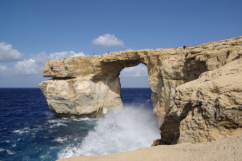
Z Wikipedii - 

The Azure Window (it-Tieqa Żerqa),  was a 28-metre-tall (92 ft) limestone natural arch on the island of Gozo in Malta. It was located in Dwejra Bay and was one of Malta's major tourist attractions.

The formation of the window was created by the collapse of a sea cave, probably during the 19th century. It consisted of a pillar of rock rising from the sea and joined to the cliff by a horizontal slab. Following decades of natural erosion that caused parts of the arch to fall into the sea, the slab and pillar collapsed completely in stormy weather on 8 March 2017.


The rock itself

Limestone is a sedimentary rock, composed mainly of skeletal fragments of marine organisms such as coral and molluscs.

The islands around Malta are significant in terms of limestone geology. On Malta you will find  Lower Corralline limestone, made up of carbonate sand and gravel, mixed with shell fossils. The carbonate sediments were originally living organisms, such as coral reefs, shells, or as very fine-grained plankton – probably on what now is Sicily. Then, these rocks were eroded, flushed south to Malta by high-energy waves and currents, and re-deposited as sand and gravel in shallow water.

The Lower Corraline limestone is hard and resistant to wear and tear, and form steep and vertical cliffs along the coast.

The Azure Window

The Azure Window developed through sea and rain erosion of a cliff face, progressing from an initial crack, then to a cave and finally an arch. It is not known exactly when the arch came to being, but the entire process is believed to have taken around 500 years.

Between the 1980s and the 2000s, parts of the top slab of the arch collapsed, significantly widening the arch. A large slab of rock on the outer edge of the cavity collapsed in April 2012, further increasing the size of the window.

In December 2016, an emergency order was published prohibiting people from going on the arch, trespassers facing a fine of €1500. However, this law was not enforced, and visitors were still walking on top of the arch days before it collapsed in March 2017.

The arch collapsed at about 9:40 am on 8 March 2017 after a period of heavy storms, leaving nothing visible above the water.The pillar gave way first, causing the top part of the arch to collapse along with it. The pillar shattered into large chunks of rock as it collapsed.
Koleiny w wapieniu - The cart ruts in Malta and Gozo

This site is one of the Cart Ruts in Gozo (other at Sannat cliffs) and Malta - close to Dingli, Naxxar and San Gwann.


There is not much information of the purpose of these ruts, and nobody knows what period of history they represent, but in any case, they are evidence of intense human activity during a particular era.

I have found three different C.R. in this location. Some of them deep some shallow with average distance between them of 110 to 140 cm.

Wikipedia:

 "cart ruts", a complex network of tracks carved in the rock. The age and purpose of the tracks is uncertain. In general, most archaeologists presume that the site developed about 2000 BC after new settlers came over from Sicily, starting the Bronze Age in Malta.

It is reported that the "Clapham Junction" nickname was given by an Englishman, who later reported that it reminded him of the busy railway station Clapham Junction in London.

Origin of the tracks

Similar tracks (known and signposted in Malta as Cart Ruts) can be found in a number of sites on both the major islands. Busewdien in St Paul's BayNaxxarSan Gwann and Bidnija are good examples on the main Island. Gozo's best are on the Ta’ Ċenċ plateau, Sannat.

Those at Misraћ Gћar il-Kbir are up to 60 centimetres (24 in) deep and have an average distance between them of 110 to 140 cm (43 to 55 in). Some cross while others form junctions, creating the illusion of a great railway station switching yard.


Research published in 2008 describes them as caused by wooden-wheeled carts eroding soft limestone. An analysis was made of the stresses that would have been caused by a cart which would fit the ruts. Professor Mottershead of Portsmouth University said "The underlying rock in Malta is weak and when it’s wet it loses about 80 per cent of its strength. The carts would have first made tracks in the soil but when that eroded, the cartwheels ran directly on the bedrock, making it easier for other carts to follow the same tracks


https://www.cartrutsmalta.com/

http://www.ancient-wisdom.com/maltacartruts.htm

*https://www.guidememalta.com/en/stranger-things-could-malta-s-so-called-cart-ruts-not-be-cart-ruts-at-all