https://www.geocaching.com/geocache/GC7A0XC
Azure Window (Lazurowe Okno) – nieistniejący już most skalny u wybrzeży wyspy Gozo w Republice Malty, położony przy Dwejra na terenie gminy San Lawrenz. Pod formacją przepływała woda morska. Lazurowe okno było jedną z najbardziej znanych atrakcji turystycznych Malty. W pobliżu znajdują się także wewnętrzna zatoka morska Inland Sea oraz skała Fungus Rock, chroniona niegdyś przez Wieżę Dwejra, jedna z tzw. wież Lascarisa.
 |
| Z Wikipedii - |
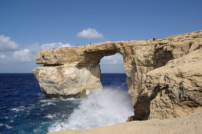
The Azure Window (it-Tieqa Żerqa), was a 28-metre-tall (92 ft) limestone natural arch on the island of Gozo in Malta. It was located in Dwejra Bay and was one of Malta's major tourist attractions.
The formation of the window was created by the collapse of a sea cave, probably during the 19th century. It consisted of a pillar of rock rising from the sea and joined to the cliff by a horizontal slab. Following decades of natural erosion that caused parts of the arch to fall into the sea, the slab and pillar collapsed completely in stormy weather on 8 March 2017.
The rock itself
Limestone is a sedimentary rock, composed mainly of skeletal fragments of marine organisms such as coral and molluscs.
The islands around Malta are significant in terms of limestone geology. On Malta you will find Lower Corralline limestone, made up of carbonate sand and gravel, mixed with shell fossils. The carbonate sediments were originally living organisms, such as coral reefs, shells, or as very fine-grained plankton – probably on what now is Sicily. Then, these rocks were eroded, flushed south to Malta by high-energy waves and currents, and re-deposited as sand and gravel in shallow water.
The Lower Corraline limestone is hard and resistant to wear and tear, and form steep and vertical cliffs along the coast.
The Azure Window
The Azure Window developed through sea and rain erosion of a cliff face, progressing from an initial crack, then to a cave and finally an arch. It is not known exactly when the arch came to being, but the entire process is believed to have taken around 500 years.
Between the 1980s and the 2000s, parts of the top slab of the arch collapsed, significantly widening the arch. A large slab of rock on the outer edge of the cavity collapsed in April 2012, further increasing the size of the window.
In December 2016, an emergency order was published prohibiting people from going on the arch, trespassers facing a fine of €1500. However, this law was not enforced, and visitors were still walking on top of the arch days before it collapsed in March 2017.
The arch collapsed at about 9:40 am on 8 March 2017 after a period of heavy storms, leaving nothing visible above the water.The pillar gave way first, causing the top part of the arch to collapse along with it. The pillar shattered into large chunks of rock as it collapsed.
