Gawlów
GPS: N50.02298 E20.46019
Gawlów
GPS: N50.02298 E20.46019
https://www.geocaching.com/geocache/GC7A0XC
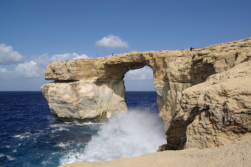
Azure Window (Lazurowe Okno) – nieistniejący już most skalny u wybrzeży wyspy Gozo w Republice Malty, położony przy Dwejra na terenie gminy San Lawrenz. Pod formacją przepływała woda morska. Lazurowe okno było jedną z najbardziej znanych atrakcji turystycznych Malty. W pobliżu znajdują się także wewnętrzna zatoka morska Inland Sea oraz skała Fungus Rock, chroniona niegdyś przez Wieżę Dwejra, jedna z tzw. wież Lascarisa.
| Z Wikipedii - |
The Azure Window (it-Tieqa Żerqa), was a 28-metre-tall (92 ft) limestone natural arch on the island of Gozo in Malta. It was located in Dwejra Bay and was one of Malta's major tourist attractions.
The formation of the window was created by the collapse of a sea cave, probably during the 19th century. It consisted of a pillar of rock rising from the sea and joined to the cliff by a horizontal slab. Following decades of natural erosion that caused parts of the arch to fall into the sea, the slab and pillar collapsed completely in stormy weather on 8 March 2017.
The rock itself
Limestone is a sedimentary rock, composed mainly of skeletal fragments of marine organisms such as coral and molluscs.
The islands around Malta are significant in terms of limestone geology. On Malta you will find Lower Corralline limestone, made up of carbonate sand and gravel, mixed with shell fossils. The carbonate sediments were originally living organisms, such as coral reefs, shells, or as very fine-grained plankton – probably on what now is Sicily. Then, these rocks were eroded, flushed south to Malta by high-energy waves and currents, and re-deposited as sand and gravel in shallow water.
The Lower Corraline limestone is hard and resistant to wear and tear, and form steep and vertical cliffs along the coast.
The Azure Window
The Azure Window developed through sea and rain erosion of a cliff face, progressing from an initial crack, then to a cave and finally an arch. It is not known exactly when the arch came to being, but the entire process is believed to have taken around 500 years.
Between the 1980s and the 2000s, parts of the top slab of the arch collapsed, significantly widening the arch. A large slab of rock on the outer edge of the cavity collapsed in April 2012, further increasing the size of the window.
In December 2016, an emergency order was published prohibiting people from going on the arch, trespassers facing a fine of €1500. However, this law was not enforced, and visitors were still walking on top of the arch days before it collapsed in March 2017.
The arch collapsed at about 9:40 am on 8 March 2017 after a period of heavy storms, leaving nothing visible above the water.The pillar gave way first, causing the top part of the arch to collapse along with it. The pillar shattered into large chunks of rock as it collapsed.
This site is one of the Cart Ruts in Gozo (other at Sannat cliffs) and Malta - close to Dingli, Naxxar and San Gwann.
There is not much information of the purpose of these ruts, and nobody knows what period of history they represent, but in any case, they are evidence of intense human activity during a particular era.
"cart ruts", a complex network of tracks carved in the rock. The age and purpose of the tracks is uncertain. In general, most archaeologists presume that the site developed about 2000 BC after new settlers came over from Sicily, starting the Bronze Age in Malta.
It is reported that the "Clapham Junction" nickname was given by an Englishman, who later reported that it reminded him of the busy railway station Clapham Junction in London.
Similar tracks (known and signposted in Malta as Cart Ruts) can be found in a number of sites on both the major islands. Busewdien in St Paul's Bay, Naxxar, San Gwann and Bidnija are good examples on the main Island. Gozo's best are on the Ta’ Ċenċ plateau, Sannat.
Those at Misraћ Gћar il-Kbir are up to 60 centimetres (24 in) deep and have an average distance between them of 110 to 140 cm (43 to 55 in). Some cross while others form junctions, creating the illusion of a great railway station switching yard.
Research published in 2008 describes them as caused by wooden-wheeled carts eroding soft limestone. An analysis was made of the stresses that would have been caused by a cart which would fit the ruts. Professor Mottershead of Portsmouth University said "The underlying rock in Malta is weak and when it’s wet it loses about 80 per cent of its strength. The carts would have first made tracks in the soil but when that eroded, the cartwheels ran directly on the bedrock, making it easier for other carts to follow the same tracks
* https://www.cartrutsmalta.com/
* http://www.ancient-wisdom.com/maltacartruts.htm
https://www.geocaching.com/geocache/GC70A38
Warownia w Owieśnie należy do typu zamków nizinnych. Zbudowano ją naplanie koła o średnicy 30 m z wewnętrznym dziedzińcem, co jest rzadkością nie tylko w Polsce. Zamek był dobrze ufortyfikowany, w średniowieczu otaczał go mur obwodowy, fosa i kolejna zewnętrzna linia murów. Wjazd prowadził od strony południowej, tam też stała wysoka wieża. Mimo kilku przebudów, które zmieniły charakter obiektu na rezydencję pałacową jego ogólny kształt pozostał nie zmieniony.
Jeżeli komuś wydaje się, że po ruinach zamków, czy pałaców, można chodzić jedynie po Dolnym Śląsku, to znaczy... że jeszcze nie był w okolicach Raciborza. A konkretniej w gminie Rudnik, która zajmuje się od niedawna wspaniałymi ruinami pałacu w Sławikowie. Poniższy tekst pochodzi ze strony goraciborz.pl i jest autorstwa pana Grzegorza Wawocznego. Zdjęcia archiwalne - Bolesław Stachow, tegoroczne - z zasobów własnych.
Dodam tylko, że jest to jedna z najpiękniejszych ruin, jakie miałam okazję podziwiać. I to słowo idealnie oddaje urok pałacu w Sławikowie.
http://www.goraciborz.pl/atrakcje/art/29.html#
Autor: Grzegorz Wawoczny
Miejscowa ludność ze strachem spoglądała nocą na potężny zamek Eickstedtów. Nie było nikogo, kto nie opowiadałby sobie o mieszkających tu maszkarach i białej damie. Sprawa zaintrygowała Josepha von Eichendorffa. Pewnej nocy ze świecznikiem w ręku wybrał się na poszukiwanie ducha kobiety. Znalazł trupa służącego.
https://opencaching.pl/viewcache.php?wp=OP8GLK
Zamek dobczycki jest przykładem zamku wyżynnego, gdyż usytuowany został na stromej górze, od południowego zachodu urwistej i zgoła niedostępnej, z płynącą u podnóża rzeką Rabą (obecnie Jezioro Dobczyckie). Stosowny dogodny dostęp znajdował się jedynie od wschodu, od strony równie wyniosłego i obwarowanego wzgórza miejskiego, od którego był odcięty głęboką fosą. Niewątpliwie najstarszy zamek wznosił się w najwyższym punkcie wzgórza nad owym niedostępnym urwiskiem, stanowiąc później zamek „górny”. Ale jeszcze w średniowieczu założenie objęło całość wzgórza, a na jego niższej platformie powstał zamek „dolny”, prawdopodobnie w miejscu pierwotnego podzamcza.