czwartek, 22 grudnia 2022

Beskid Wyspowy

Charakterystyczną cechą Beskidu Wyspowego jest "wyrastanie" odosobnionych, wyspowo wznoszących się szczytów z typowo podgórskiego, sfalowanego łagodnymi garbami krajobrazu. Szczyty te mają strome, czasem nawet bardzo spadziste stoki, wierzchowina jednak z reguły jest płaska i wylesiona. 

Beskid Wyspowy jest krainą łączącą w sobie cechy podgórskie z górskimi. Góry nie łączą się tu w zasadzie w długie pasma, lecz tworzą jakby szereg wysp otoczonych głębokimi i szerokimi dolinami.

środa, 14 grudnia 2022

Bochnia - cmentarze wojenne z I WŚ

https://www.geocaching.com/geocache/GC3K0F7

CW 313 Bochnia


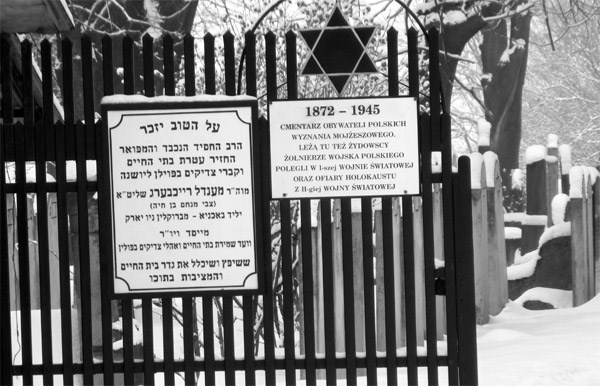
Cmentarz nr 313 w Bochni znajduję się na terenie kirkutu żydowskiego na wzgórzu Krzeczków. Dojście od rynku ulicami Gazaris, Modrzejewskiej i Krzeczków. Kirkut żydowski jest zamknięty dla zwiedzających.

Cmentarz nr 313 składa się z dwóch rzędów macew z Gwiazdą Dawida (26 pojedynczych mogił). Elementem centralnym jest większa macewa na której znajduję się napis w języku hebrajskim i polskim:

GROBY POLSKICH ŻOŁNIERZY WYZNANIA MOJŻESZOWEGO POLEGŁYCH W I WOJNIE ŚWIATOWEJ 1914-1918.

Fundatorem tablicy jest rabin Mendel Reichberg z Nowego Jorku

Istnieje możliwość zwiedzania kirkutu, niestety w czasie gdy zdecydowana większość obywateli tego kraju jest w pracy czyli od poniedziałku do piątku w godzinach od 8 do 15.

piątek, 2 grudnia 2022

Macedonia Środkowa - Grecja kontynentalna

 Macedonia Środkowa - Grecja kontynentalna

Macedonia - Grecja kontynentalna

 Macedonia jest największym regionem Grecji (licząc zachodnią, wschodnią i środkową), tu znajdują się Saloniki - drugie co do wielkości miasto kraju.

Wieże na Morzu Egejskim - Unesco

The numerous ancient towers scattered across many Aegean islands (Amorgos, Andros, Thasos, Ikaria, Kea, Kythnos, Mykonos, Naxos, Serifos, Sifnos, Skiathos, Paros, Tinos, etc.) and the mainland, constitute a particular type of ancient building with various uses. The vast majority of the towers are dated to around the mid-4th c. BC and up to the first quarter of the 3rd c. BC. Despite their numbers and dispersal, they present common architectural features, such as their circular, square or rectangular plan and their sturdy construction of local stone.

Tracja - Grecja kontynentalna


TRACJA

historycznie: starożytna kraina położona między dolnym Dunajem, Morzem Czarnym, Morzem Egejskim i rzeką Strymon. Obecnie region geograficzny w granicach Bułgarii, Grecji i Turcji, znajdujący się m.in. na terenie Niziny Trackiej. Ze względu na skupisko ludności muzułmańskiej i kulturalne związki z Bułgarią i Turcją, ma zupełnie inny charakter niż pozostała część Grecji kontynentalnej.


National Park of Dadia - Lefkimi - Souflion

Unesco tentative list


Situated at the southeast end of the Rhodope mountain range, at the crossroads of two continents, the National Park of Dadia-Lefkimi-Soufli Forest (DNP) is of exceptional ecological significance at European level. Characterised by a rich habitat mosaic on a network of low hills in a transitional climate zone between the Mediterranean and the continental, the DNP extends over an area of 42,800ha in Evros Prefecture. It is located at the easternmost edge of a huge forested area that extends all the way west and north along the Rhodope mountain range, while major forested areas are absent for hundreds of kilometres eastwards. Pine trees predominate in the area of the National Park, forming coniferous forests of Pinus brutia, with P. nigra found at the lowest altitudes of its known distribution, while mixed and deciduous forests also occur over a large expanse. Geologically, the northern part of the DNP is dominated by Tertiary ophiolith complexes, while the south mainly consists of Paleogene volcanic and sedimentary rocks. The location of the DNP, on one of the most important migration routes for birds of the Western Palearctic, makes this forest one of the few regions in Europe cohabitated by 36 out of the 38 European raptor species, where three of the four European species of vulture (Aegypius monachus, Neophron percnopterus and Gyps fulvus) co-exist. The resident Black Vulture population in particular is of great importance, as it is the last remnant of an initially large population of the species within the Balkan region, while the presence of the endangered Egyptian vulture is also significant.


Grecja - średniowieczne fortyfikacje (UNESCO - lista oczekujących)

 LATE MEDIEVAL BASTIONED FORTIFICATIONS IN GREECE


Unesco tentative list


With the appearance and establishment, in the 15th century, of the use of gunpowder, a new, powerful and destructive means of warfare, city fortification practices changed. Since medieval fortifications were unable to withstand the constantly increasing artillery power, additional defensive structures began to be added to existing fortresses. This change was completed in the 16th century, establishing the “bastion system” or “fronte bastionato”, based on the principle of “flanking fire”. In the 17th century, the need to confront even greater artillery firepower led to the construction of a multitude of smaller fortifications outside the main moat, whose aim was to keep the enemy as far away as possible from the main fortifications. Finally, up to the end of the 18th century, fortification architecture would continue to be based on the principles of the 16th century, while of course following the development of artillery. This development is documented by a series of fortifications on Greek territory. These fortifications are mostly found in areas that passed into Latin hands, such as the Peloponnese, the coasts of Western Greece, the Ionian Islands, Crete and the Dodecanese. Most were built on the site of older, ancient and/or Byzantine fortifications, but their main phase was constructed during the various phases of Latin domination. These are particularly well-preserved fortification works, which largely retain their integrity and original layout intact to the present day. This is very significant, given that they were built by the leading engineers of the time and closely follow developments in the field of defensive art. In recent years restoration projects for their protection and enhancement have taken place preserving however their particular character and their relation to the surrounding area. The fortifications also contribute to the study of the urban areas of which they form a part, providing valuable information on the organisation of urban planning, which they determined in several cases. The proposed fortifications are strategically positioned on the hubs of the trade routes between West and East and also North and South, and therefore played an important part as trading stations in the East Mediterranean basin.


SITE

REGION

REGIONAL UNIT

COORDINATES

Corfu

Ionian islands

Corfu

19.928385 E, 39.624538 N

Zakynthos

Ionian islands

Zakynthos

20.891944 E, 37.789444 N

Koroni

Peloponnese

Messinia

21.961826 E, 36.794382 N

Methoni

Peloponnese

Messinia

21.700 E, 36.8150 N

Bourtzi-

Palamidi-

Akronafplia

Peloponnese

Argolis

22.790586 E, 37.569689 N

22.804472 E, 37.561486 N

22.795028 E, 37.563869 N

Heraklion

Crete

Heraklion

25.136743 E, 35.344548 N

Chania

Crete

Chania

24.013659 E, 35.518245 N

Rhodes

South Aegean

Rhodes

28.2270 E, 36.4450 N

Mytilini

North Aegean

Lesbos

26.561829 E, 39.110116 N